Photos with this report (click to enlarge) | |||
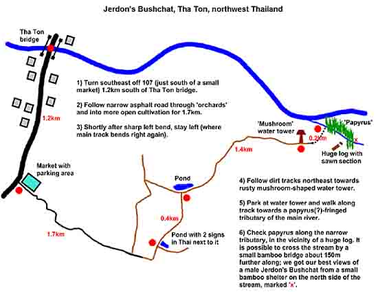
 Jerdon's Bushchat map |
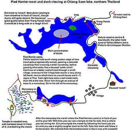
 Pied Harrier roost map |
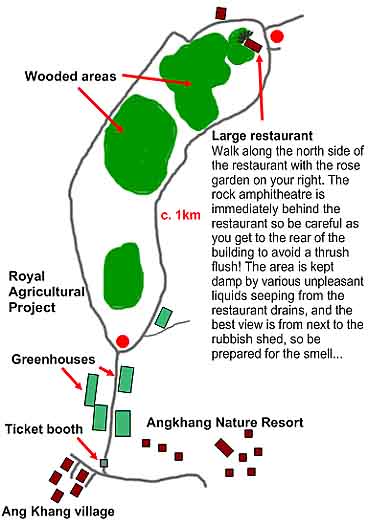
 Dark-sided Thrush map |
|
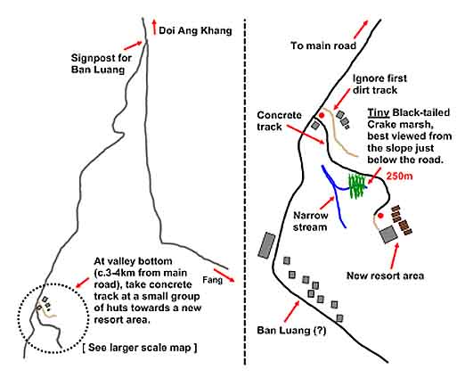
 Black-tailed Crake map |
|||
The purpose of this short report is to provide some details on a recent three-day trip made to Doi Lang, a 2200m forested mountain on the Thai-Burmese border, and to supplement the information available on some of the other lesser-known sites we visited as part of 10-day trip to the Chiang Mai area of Northern Thailand. We have not included full details of Doi Ang Khang or anything about Doi Chiang Dao because information on these areas is readily available (try www.thaibirding.com for starters).
As veterans of previous trips to Northern Thailand, and various parts of the Himalayas, including Eagle’s Nest, we can whole-heartedly recommend Doi Lang as an easy and prolific birding destination. We enjoyed a heady mix of Palaearctic winterers and temperate Asian forest species, with easy viewing on near-empty roads and trails, and bird activity remained high throughout most of the day. Doi Lang is actually well-known and much-frequented by Thai birders; we met almost 15 during our short visit (in contrast to none at more ‘well-known’ – at least to westerners - locations). By lunchtime on our first day, we had found out why, and entirely dispelled any lingering doubts that we should have used our three-day ‘birding pass’ for a return visit to Doi Inthanon.
GETTING THERE
The starting point for Doi Lang is the small town of Tha Ton, an easy 3 hour drive north from Chiang Mai on the Chiang Dao / Fang road and with convenient Jerdon’s Bushchats by the river close to town. We rented a car from www.journeycnx.com. Aside from Chiang Mai’s chronic congestion and the inevitable maverick mopeds, self-driving in Thailand is easy.
SLEEPING & EATING
It appears possible to camp on Doi Lang; this would be an original, cheap and convenient option, albeit a rather chilly one. The alternative to this is accommodation in Tha Ton; we stayed at the very reasonable Garden Home Resort. This, and a number of other decent choices (see, for example, Lonely Planet) are situated just north of the main bridge in Tha Ton, mostly west of the main road (107) and along the river. Our choice had a good restaurant and beautiful forested grounds (although, to be honest, we never saw these in the daylight!). There is no food available on Doi Lang itself so leave Tha Ton well-prepared if you’re planning a day-long assault.
GETTING ONTO THE MOUNTAIN
The turn-off for Doi Lang is reached by heading south on Rt. 107 from the bridge in Tha Ton and soon turning right (west) onto Rt. 1314 (beside the Bangkok Bank ATM). All the distances in the following account are given from this junction. The total journey time to the top from here is about one hour and the road, while narrow and steep in places, is sealed all the way.
At km13.5, turn right past a small checkpoint. (There are a number of such small, checkpoints on the hill, maintained in a seemingly low-key, haphazard fashion by friendly and presumably bored low-rankers in the Thai army. They may record your name and car registration but otherwise had only waves for birders, whom they appear to be well-acquainted with).
The road climbs steadily from here, before descending to an extensive terraced hillside at km27.0. We did some (mostly nocturnal) birding close to the big bridge at km23.3 (see species list) and the terraced paddies are worth checking for Jerdon’s Bushchat (breeds here in at least some years), but Doi Lang proper starts on the ascent above the rice paddies and we concentrated our efforts further uphill.
SUGGESTIONS FOR BIRDING DOI LANG
Birding is best carried out from the sealed road. This is empty of traffic (even during our New Year visit), the vistas are great and, once above a big clearing at km31.8, the forest is pristine right along the road. We also checked a couple of likely looking trails in search of deep shade species. The whole area from km31.8 upwards is worth covering, but we particularly recommend:
Km32.6 Black-breasted Thrush was easy here at dawn on the road verges and we found a seeding tree holding both Spot-winged Grosbeak and Scarlet Finch.
Km34 (approx) A short trail on the right leads down towards a gushing torrent. Exploring this led to Slaty-bellied Tesia and the whole area looked good for gamebirds and damp-leaf specialities.
Km34.7 Here is the main checkpoint and associated shacks. There is a likely-looking trail on the right, just before you reach the checkpoint, but we didn’t get round to trying it. The forest downhill from here all the way back to km32.6 and beyond was excellent. Our favourites here included three species of shrike-babbler, Vivid Niltava, Crested Finchbill, Asian Emerald Cuckoo, Spectacled Barwings and three species of sibia.
Uphill of km34.7, Red-flanked Bluetails become common and very easy to see as they feed along or on the road. We located a Golden Bush Robin doing likewise at km35.3. A bit further up, at km35.5, there is a large, mossy tree set back a little from the forest edge on the left hand side. We were surprised and thrilled to discover three Cutias on the top snags, as they briefly joined a flock that we had been stirring up with a passable impression of a Collared Owlet. We later learnt that this is a known spot for Cutias, though clearly not too frequently to judge from the envious exclamations we got from local birders when we mentioned this sighting to them.
Km39.2 Here a big open ridge appears on the right, exposing Burma across the valley. We saw little in the open scrub here, but hiked about 1.5 km further, almost to the end of the drivable road (which is marked by a cavernous hole). Up here white-eyes, sunbirds and perplexing array of leaf-warblers dominated.
Km40.2 There is a good trail on the left here. We explored this and found plenty of birds, most notably another Slaty-bellied Tesia and a small group of Red-faced Liocichlas.
FINDING JERDON'S BUSHCHAT AT THA TON
1.2km south of the Tha Ton bridge, an asphalt road leads east into agricultural land on the flood plain of the Maekok river. The turn-off is immediately south of a small market on the east side of the road. Following this road about 3.5km to a rusty mushroom-shaped water tower (visible from the main road north of Tha Ton bridge, but only accessible from the south side of the river) leads to a great spot for Jerdon’s Bushchat. Full access details are found in the attached map; please email us at nickmoran76 at yahoo.co.uk if you want a higher resolution version. In addition to the bushchat, the surrounding farmland produced our only Rufous-winged Buzzard and Chestnut-capped Babblers of the trip, numerous Common Stonechats, Pied and Grey Bushchats and a range of other ‘junk habbo’ birds.
GPS reference for Jerdon’s Bushchat: N 20º 02’44” E 99º 23’09”
CHIANG SAEN LAKE AND PIED HARRIER ROOST
The outside possibility of Baer’s Pochard (no records so far in the winter of 2008-09), not to mention the spectacle of a sky-full of Pied Harriers, was enough to entice us right up to the Golden Triangle for a day. We based ourselves in the luxurious yet friendly Viang Yonok hotel http://www.viangyonok.com/ for a night, making full use of our 24 hours there by cycling the north-eastern shore of the lake in the morning, birding the Mekong northwest of Chiang Saen in the middle of the day, also by bike, then driving to the harrier roost in the late afternoon.
Details of how to find the harrier roost and where best to view the ducks are provided on the attached map; again you can email us at nickmoran76 at yahoo.co.uk for a clearer version. In addition to the once-in-a-lifetime sight of over 60 Pied Harriers swirling above our heads, other good sightings in the area included White-browed Crake from the parking area just south of Viang Yonok hotel, Pallas’s Grasshopper Warbler, Ruddy-breasted Crake and several Yellow Bitterns from the boardwalk at the Nature Reserve HQ, 1 Avocet and over 150 Little Pratincoles on the gravel bar in the Mekong from the most north-westerly restaurant on the road out of Chaing Saen, and a single Long-billed Plover about 3km further upstream.
GPS reference for Pied Harrier roost: N 20º 13’44” E 100º 01’04”
GPS reference for duck view-point: N 20º 15’39” E 100º 02’15”
DOI ANG KHANG
We enjoyed 3 days of fairly low-key but very rewarding birding at Doi Ang Khang over Christmas, based in the plush Amari Angkhang Nature Resort http://www.amari.com/angkhang/
The trails at km19-22 on the road to Ang Khang are well-covered elsewhere on the net, so we haven’t repeated details here. However, we did misread the information we had on the rock amphitheatre behind the restaurant in the Ang Khang Royal Agricultural Project, hence the map for that location. Here we were treated to an unforgettable Zoothera show, with Scaly and Dark-sided Thrushes feeding side-by-side in full view, accompanied by several Black-breasted Thrushes! Just a couple of hours earlier that afternoon, bumping into a friend of Oscar’s on one of the trails had provided us with both this information and gen for a shoo-in Black-tailed Crake at Ban Luang; a map is also provided for the latter site.
ACKNOWLEDGEMENTS
Many thanks to Neil Lawton who provided us with Chiang Saen and Jerdon’s gen, and the initial inspiration for a trip to Doi Lang followed up by all the gen he had on what to do once we got there.
We’re also grateful to Jim Scott; a chance meeting at Doi Ang Khang killed two awesome birds with one stone as he corrected our mistake regarding the location of the Dark-sided Thrush in the Royal Agricultural Project and pointed us in the direction of a ridiculously showy Black-tailed Crake at Ban Luang.
DOI LANG ONLY
Broad altitudinal details are presented below, with the categories lower (below km27 rice paddies), middle (between km27 and the km34.7 checkpoint) and upper (above km34.7). Numbers refer to daily maxima recorded.
1. Rufous-throated Partridge Calling only, Upper
2. Mountain Bamboo-Partridge 5, Lower
3. Red Junglefowl Calling, Lower, at dawn
4. Bay Woodpecker One, Middle
5. Stripe-breasted Woodpecker 3, Middle
6. Golden-throated Barbet 4, mostly Middle
7. Great Barbet 2, Lower and Middle
8. Blue-throated Barbet 1, Middle
9. Greater Coucal 1, Lower
10. Large Hawk Cuckoo 1 flying by km23.3 bridge at dusk
11. Asian Emerald Cuckoo 1, Middle
12. Pacific Swift Total 80 in one flock
13. Collared Owlet Calling, Upper
14. Mountain Scops-Owl Calling at km20.9 before dawn
15. Asian Barred Owlet Calling from bridge at km23.3 at dawn
16. Grey Nightjar At dusk 1-2 very obvious on road at approx km22, with one singing from a snag
17. Oriental Turtle-Dove 30, all in paddies
18. Emerald Dove 1, Upper and Middle
19. Crested Goshawk one displaying, Middle
20. Mountain Hawk-Eagle 1, Upper
21. Striated Heron 2 in paddies
22. Orange-bellied Leafbird 12; mostly Upper
23. Long-tailed Shrike 2, Lower
24. Grey-backed Shrike 1, Middle
25. Spangled Drongo 25+, mostly Middle
26. Ashy Drongo 3, Lower
27. Grey Treepie 20+, mostly Middle
28. Grey-chinned Minivet 2, Middle
29. Scarlet Minivet 2, Middle
30. White-throated Fantail 1, Upper
31. Chestnut-bellied Rock-Thrush 1, Lower
32. Black-breasted Thrush 3-4 on road, Middle
33. Grey-headed Canary-Flycatcher 2, Upper and Middle
34. Slaty-blue Flycatcher 3+, all Lower: very skulking in scrub
35. Vivid Niltava One treetop female, Middle
36. Oriental Magpie-Robin One, Lower
37. Siberian Rubythroat Male on road at dawn, km27.7
38. Red-flanked Bluetail 10, mostly Upper
39. Golden Bush-Robin Female, Upper
40. Siberian Stonechat 3, paddies
41. Grey Bushchat 3, paddies
42. Chestnut-vented Nuthatch 8; Middle and Lower
43. Yellow-cheeked Tit 4 Upper and Middle
44. Yellow-browed Tit 2, Upper and Middle
45. Black-throated Tit 5 Upper and Middle
46. Barn Swallow 1, Lower
47. Crested Finchbill 2, Upper and Middle
48. Black-crested Bulbul 4, Upper and Middle
49. Sooty-headed Bulbul 10, Lower
50. Flavescent Bulbul 20+, mostly Upper
51. Striated Bulbul 15, mostly Middle
52. Ashy Bulbul 20, Upper and Middle
53. Black Bulbul 6, Upper and Middle
54. Mountain Bulbul 6, Upper and Middle
55. Hill Prinia 2, Upper
56. Mountain Tailorbird 1, Upper
57. Slaty-bellied Tesia 2; one on each trail tried (see above)
58. Buff-throated Warbler One, Upper
59. Greenish / Two-barred Greenish Warbler One, Lower. Good luck!
60. Yellow-browed Warbler Several Lower only
61. Pallas’s Warbler 5, Upper and Middle
62. Buff-barred Warbler 3+, Upper and Middle
63. White-tailed Leaf-Warbler 15+, mostly Upper
64. Chestnut-flanked White-eye 20+, Upper
65. Red-faced Liocichla 3, Upper
66. Chestnut-crowned Laughing Thrush 4, Upper and Middle
67. Pygmy Wren-Babbler 3 singing, Upper and Middle
68. Spectacled Barwing 10, Upper and Middle
69. Dark-backed Sibia 20, mostly Upper
70. Rufous-backed Sibia 2, Middle
71. Long-tailed Sibia 3, Middle
72. White-browed Shrike-Babbler 2, Middle
73. Chestnut-fronted Shrike-Babbler 2, Middle
74. Black-eared Shrike Babbler At least 2, Middle
75. Blue-winged Minla 10, Upper and Middle
76. Rufous-winged Fulvetta 6, Upper and Middle
77. Grey-cheeked Fulvetta 30+, Upper and Middle
78. Whiskered Yuhina 10+, Upper and Middle
79. Mrs Gould’s Sunbird 50+, almost all Upper
80. Black-throated Sunbird 2, Upper and Middle
81. Olive-backed Pipit 5, paddies
82. Grey Wagtail 2, paddies
83. Common Rosefinch 6, Lower
84. Scarlet Finch 2 sub-adult males, Middle
85. Spot-winged Grosbeak 10 in flock, Middle